
IN THE SUPERIOR COURT OF LEE COUNTY
STATE OF GEORGIA
|
SABAL TRAIL TRANSMISSION, LLC,
Plaintiff,
vs.
JAMES E. BELL, II and ROBERT A. BELL,
Defendants. |
: : : : : : : : : : : : : : : : |
Civil Action No. 14-CV-208RS
|
 AMICUS CURIAE OF WWALS WATERSHED COALITION, Inc.
IN SUPPORT OF DEFENDANTS THE BELLS
COMES NOW WWALS WATERSHED COALITION, INC. (WWALS), as friends of the court and concerned citizens in the above-entitled action in support of the Defendants and file this their brief with the court in the above referenced case and states as follows and provides in support thereof the following:
Table of Contents
3.a. Evidence of the hazards 5
3.a.i. Withlacoochee River Georgia leaks into Floridan Aquifer 7
3.a.ii. Floridan Aquifer fragile across the state line into Georgia 14
3.a.iii. Sabal Trail moved off the Withlacoochee River in Florida 18
3.a.iv. Sinkholes at new Sabal Trail Suwannee River crossing 22
1. STATEMENT OF INTEREST
WWALS Watershed Coalition, Inc. (WWALS) is a Georgia nonprofit corporation and an IRS 501(c)(3) educational corporation advocating for conservation of the entire watersheds of the Withlacoochee and Alapaha Rivers in south Georgia and north Florida.1 Sabal Trail Transmission LLC (Sabal Trail) proposes a natural gas pipeline under our Withlacoochee River, and through multiple counties in our watersheds, specifically Colquitt, Brooks, and Lowndes Counties, Georgia and Hamilton County, Florida. WWALS is an intervenor against Sabal Trail’s pipeline in FERC Docket No. CP15-17.2 This is the same pipeline Sabal Trail proposes through Mitchell County, Georgia, location of the subject property of this case. The WWALS Board of Trustees voted 8 April 2015 to send this brief to the court to object to Sabal Trail’s attempts to claim Georgia eminent domain. Any such grant of eminent domain could have adverse effects on the Floridan Aquifer, which is the source of almost all water for drinking, agriculture, and industry in WWALS’ watersheds, by facilitating the implementation of that environmentally damaging and hazardous pipeline, including destructive surveying and test wells long before any potential grant of a federal permit. Such hydrogeology concerns have already caused Sabal Trail to move off the Withlacoochee River in Florida. The same karst geology concerns continue to apply across the state line where Sabal Trail still proposes to cross the Withlacoochee River in Georgia .
1No counsel for a party authored this brief in whole or in part, and no counsel or party made a monetary contribution intended to fund the preparation or submission of this brief. No person other than amicus curiae, its members, or its counsel made a monetary contribution to its preparation or submission.
2WWALS Watershed Coalition, Inc., “Motion to Intervene of WWALS Watershed Coalition, Inc. under CP15-17, et. al.” FERC Accession Number 20141222-5054, 22 December 2014.
2. SUMMARY OF ARGUMENT
Both federal and state law require balancing any alleged need for a new pipeline against adverse environmental consequences. The Federal Energy Regulatory Commission (FERC), to which Sabal Trail has applied for a permit, once denied a pipeline application because of adverse consequences on the owners of an underground salt dome. Any alleged need for Sabal Trail’s proposed pipeline should have to meet a much higher standard to approach counterbalancing damage to the water supply for this entire region.
In Georgia, while O.C.G.A. 22-3-81 (1) defines “pipeline” as for “the transportation of petroleum or petroleum products in or through this state” it does not define petroleum products. The U.S. Energy Information Agency and the American Petroleum Institute define natural gas as a petroleum product. Therefore O.C.G.A. 22-3-84 applies to natural gas pipelines, and the language about natural gas pipelines in O.C.G.A. 22-3-88 further limits the applicability of eminent domain defined in previous sections from O.C.G.A. 22-3-80 onwards.
O.C.G.A. 22-3-84 requires any exercise of Georgia eminent domain by a pipeline company to be preceded by a permit from the Georgia Environmental Protection Division demonstrating similar counterbalance against “undue hazard to the environment and natural resources of this state”. No such permit has been granted, and Sabal Trail has not even provided any evidence that hearings for such a permit have been held or have even been announced.
For these and other reasons described in this brief, WWALS respectfully requests the court to rule against Georgia eminent domain authority for Sabal Trail.
3. ARGUMENT
3.a. Evidence of the hazards
The karst limestone geology containing the Floridan Aquifer is fragile and easily damaged, as evidenced most recently by a filing by FERC itself in its Sabal Trail docket CP15-17, and by multiple studies by the U.S. Geological Survey (USGS), the Suwannee River Water Management District (SRWMD), and professors at Valdosta State University (VSU), including the ones described in this brief and illustrated in exhibits.
Both Florida and Georgia geological experts have expressed concerns about drilling under the Withlacoochee River, which is in WWALS watersheds. The technique proposed is HDD or horizontal-directional drilling; see Sabal Trail’s “How We Cross Rivers & Streams” in Exhibit A. Quoting from “Summary of the April 1, 2015 interagency meeting held among FERC staff, Florida Department of Environmental Protection, et al regarding the Southeast Market Pipelines Project under CP14-554 et al.” FERC Accession number 20150401-4004, 1 April 2014:
JANUARY 22, 2015 — FLORIDA KARST MEETING
The FERC staff met with representatives from the Florida Department of Environmental Protection (FDEP), Florida Geological Survey (FGS), Florida Park Service (FPS), Suwannee River State Park, Suwannee River Water Management District (SRWMD), and Southwest Florida Water Management District (SWFWMD). The meeting was held at FGS offices in Tallahassee, Florida. …
- Sabal Trail karst characterization methods — existing databases and mapping; aerial photographic interpretation; geotechnical studies; geophysical studies.
- Sabal Trail underestimated karst features—additional, more recent data available from agencies including LiDAR, potentiometric surface maps, and cave maps.
- Highest agency concern is associated with likely loss of drilling fluid associated with HDDs in limestone bedrock including at the Suwannee, Santa Fe, and Withlacoochee rivers.
- Drilling fluid loss would have an environmental impact; risk and magnitude of impact on groundwater, wells and springs should be based on updated, site-specific information.
- Sabal Trail karst mitigation measures—procedures to limit HDD drilling fluid loss; surface water, water well, and spring monitoring and mitigation plans; and sinkhole mitigation procedures.
- Monitoring and mitigation plans should be based on updated, site-specific information and flow regimes at time of construction.
- Consider using construction materials (sand, gravel, cobble) to mitigate sinkholes and other karst features encountered during construction.
- High volumes of grout can locally affect aquifer quality and recharge.
- Polymers not historically successful in preventing drilling fluid loss.
- Pipeline right-of-way should be inspected for signs of sinkhole activity after major rain events.
- Private landowner adjacent to Suwannee River State Park opposes construction on his property, which is within a conservation easement. Minimize operating right-of-way if overland route occurs within the park.
Emphasis added on Withlacoochee rivers. For the private landowner, see the section below on Sinkholes at new Sabal Trail Suwannee River crossing.
In the same 1 April 2015 FERC filing:
FEBRUARY 4, 2015 — GEORGIA KARST MEETINGThe FERC staff met with Mr. Jim Kennedy, Georgia State Geologist, via conference call. The primary purpose of the meeting was to discuss Georgia geologic and hydrogeologic information presented by Sabal Trail in its FERC application and other supplemental filings. Topics discussed included: …
- One HDD would encounter limestone bedrock (Withlacoochee River).
- Discussed sinkhole development near Albany municipal well field.
Emphasis added on Withlacoochee River. The only place Sabal Trail’s current proposed preferred route would cross the Withlacoochee River is just south of US 84 between Brooks and Lowndes Counties in Georgia. Amicus WWALS is very concerned about that crossing, and the other crossing at I-75 on three alternate routes, both because the Withlacoochee River continues to form sinkholes that leak into the Floridan Aquifer, and because similar concerns just across the state line already caused Sabal Trail to move off the Withlacoochee River in Florida.
3.a.i. Withlacoochee River Georgia leaks into Floridan Aquifer
Sinkholes on the Withlacoochee River north of Valdosta that leak into the Floridan Aquifer have already forced the City of Valdosta to double the depth of its water wells, and have forced the County of Lowndes to spend more than $300,000 on a sinkhole under a road.
Valdosta’s water wells are now 400 feet to get below Withlacoochee River water in the aquifer. See 1 January 1999 USGS study, Box E on Page 63 in Exhibit B.
As USGS noted, water underground travels for miles, and often not in the same direction as the Withlacoochee River (or any river) flows above-ground.
According to the City of Valdosta’s Water Treatment web page, accessed 3 April 2015:
Where Does Your Water Come FromThe City of Valdosta obtains its water supply from eight (8) wells that are drilled into an underground layer of porous, water bearing limestone known as the Upper Floridan Aquifer. This limestone layer lies under most of South Georgia and all of Florida. Generally, the aquifer is able to provide a prolific supply of good clean water. In Valdosta, the top of the aquifer lies approximately 200 feet below ground surface and the City’s wells are drilled an additional 200 feet into the limestone. The Floridan Aquifer in the area of Valdosta and Lowndes County is known as a karst aquifer. This is an aquifer that has cracks, underground solution channels, and caverns. These cracks can provide a route to allow contaminants to enter the aquifer, move about in the aquifer and alter the water supply and can cause special challenges for the City’s water system.Formation of such sinkholes has not stopped. Geology Professor Don Thieme of Valdosta State University has documented a sinkhole that formed within two months at the junction of Cherry Creek with the Withlacoochee River. This Cherry Creek Sink is in the same sinkhole area marked on the USGS map in Illustration 1 above. As you can see in Exhibit C, which is a picture with a man standing inside, the Cherry Creek Sink is large.
Prof. Thieme remarks that in 2014 slides (see Exhibit C) that the rock formations under those sinks are:
- more pronounced and consistent than can be inferred from previous descriptions
- very hydrologically significant for Withlacoochee River at Valdosta! !
Prof. Thieme and colleagues have mapped many other sinkholes throughout Lowndes County, including the one under a house garage east of the Withlacoochee River pictured 28 August 2012 in Exhibit D.
In 2007, a sinkhole opened under Snake Nation Road in Lowndes County, west of the Withlacoochee River sinkhole area marked on the USGS map in Exhibit B. This sinkhole was closer to the Withlacoochee River’s tributary, the Little River. Lowndes County filled it in, but as reported by Jade Bulecza for WALB TV in “Sinkhole opens in Lowndes County” on 1 November 2010, this sinkhole reappeared 30 October 2010, as shown in the picture in Exhibit E.
Kay Harris reported for the Valdosta Daily Times in “Solutions to fixing sinkhole not easy” on 19 November 2010,
The Snake Nation Road sinkhole has proven a more difficult problem than originally expected. It is believed an underground cavern is causing the ground to collapse.Lowndes County Engineer Mike Fletcher said the county hired Geohazards to conduct a geological survey around the hole. By drawing grids north and south, east and west, extending 550 feet around the hole, the company has found a large section adjacent to the hole that is in danger of collapsing as well as a second area farther down the road.“This is much more serious than we first thought,” said Fletcher. “We are looking at our options now to see what can be done.”Jade Bulecza reported for WALB TV in “Lowndes Co. finds a sinkhole solution“, 1 April 2011,
Snake Nation Road will be adjusted northward so motorists can go around the hole, and they’re hoping to start work on it sometime this summer.They estimate the project will cost about $300,000. About three years ago the sinkhole opened for the first time and contractors put in about 12,000 yards of broken concrete and rubble to fill it up."We thought what we had was a good base to build a road back up but unfortunately that material is gone and were not sure where it’s gone to but it’s no longer there," said County Engineer Mike Fletcher.Officials say the option they chose is more cost effective than filling it up and building a road over it. They also say a sonar detected another sinkhole underneath ground on snake nation road right beside the current one.The area around the Withlacoochee River in south Georgia (see Exhibit F) is riddled with underground caverns that easily form sinkholes, in creeks, under garages, and under roads. Such sinkholes have already cost the City of Valdosta and the County of Lowndes substantial sums. We do not need an additional risk of sinkholes that could leak into our drinking water in the Floridan Aquifer or cause further property damage. This is not a good place to put a new pipeline, especially one as large as Sabal Trail proposes: 36-inch diameter plus another 12 inches for each borehole.
3.a.ii. Floridan Aquifer fragile across the state line into Georgia
The Georgia-Florida state line does not interrupt underground hydrology.
In a letter of 27 March 2014 to Laura P. Milligan, personnel of the Florida Department of Environmental Protection (FL DEP), including the map in Exhibit G. That letter noted:
In some local areas horizontal drilling near streams and rivers could impact local flow systems. The deeper horizontal drilling required to pass under large rivers like the Suwannee could potentially intercept karst conduits. Some possibility of restriction or redirection of groundwater flow exists. This could affect groundwater flow to local springs and impact Minimum Flows and LevelsThey included the map on the right above in Illustration 7, showing Sabal Trail’s proposed path going through the most vulnerable areas of the Floridan Aquifer in north Florida.
The vulnerability of the Floridan Aquifer does not stop at the state line, as you can see in the map in Exhibit H from USGS 19 April 2012, Lowndes and Brooks Counties Georgia continue the same affected area of the above map. The Floridan Aquifer extends all the way under Sabal Trail’s proposed path through Colquitt, Dougherty, and Mitchell Counties to Lee County, Georgia, underneath the subject property and the Leesburg courthouse.
The Georgia Water Coalition (GWC) is a group of more than 200 organizations representing well over a quarter of a million Georgians; WWALS is a GWC partner. Annually GWC publishes the Dirty Dozen, A list of the “Worst Offenses Against GEORGIA’S WATER.” In Georgia Water Coalition Dirty Dozen 2014, item number 9 is “Withlacoochee River & Floridan Aquifer: Gas Pipeline Threatens Southwest Georgia Water, Way of Life”, which begins:
“The Sabal Trail pipeline’s path across southwest Georgia would require boring underground pipelines beneath the Withlacoochee, Flint and Chattahoochee rivers as well as numerous smaller streams, and will course underground above the Floridan aquifer. While the Sabal Trail pipeline’s parent companies would have residents believe their 3-foot-diameter pipe is a benign neighbor, the history of gas pipeline accidents and environmental ills paints a different picture.”Clearly there are significant problems with routing a 36-inch pipeline under rivers and through a drinking-water aquifer in fragile karst limestone, and significant public opposition. Opposition in Florida already moved the Sabal Trail pipeline off the Withlacoochee River in that state for similar reasons.
3.a.iii. Sabal Trail moved off the Withlacoochee River in Florida
Ann B. Shortell, Executive Director of Florida’s Suwannee River Water Management District, told FERC (“Comment letter and technical memorandum of Suwannee River Water Management District under PF14-1.” FERC Accession Number 20140418-5169, 18 April 2014) of numerous concerns about blasting, testing water extraction and wastewater, and these items:
Portions of the route may pass through shallow karst with extensively developed cavernous porosity. Shallow caves may be of sufficient size to preclude installing effective support for the pipe.
Grouting in cavernous porosity zones may be ineffective. Excessive grout pumping may cause localized groundwater contamination if pumped into flow systems.
Horizontal directional drilling in cavernous karst has potential to trigger sinkhole formation or disruption of natural groundwater flow patterns.
When Sabal Trail proposed to cross the Withlacoochee River in Florida, Hamilton County, Florida resident Chris Mericle (now a WWALS board member), posted a video, “Our Holly Point Treasures”, on YouTube (13 July 2014; see Exhibit I) of many of the springs and sinks in or near the Withlacoochee River around the area Sabal Trail proposed to cross. One is pictured on the right here in Illustration 9.
Chris Mericle commissioned a hydrogeological study by Geologist David Brown, “Sabal Trail methane pipeline crossing of Withlacoochee River”, 22 August 2014 (see Exhibit J) which includes numerous instances of sinkholes near the Withlacoochee River in Florida, and the illustrations in Exhibit J of further sinkholes as a possible consequence of drilling under that river.
The same kind of frac-out could occur under the Withlacoochee River in Georgia.
As a result of such evidence of environmental hazards from the proposed Sabal Trail pipeline, the Hamilton County Board of Commissioners passed RESOLUTION 2015-02 on 22 August 2014 asking Sabal Trail to move off of the Withlacoochee River in Florida. The Hamilton County Board of Commissioners also later filed “Motion to Intervene of Hamilton County, Florida Board of County Commissioners under CP15-17. “, FERC Accession Number 20141218-5333, 18 December 2014, https://elibrary.ferc.gov/idmws/file_list.asp?document_id=14282868 .
Chris Mericle and Hamilton County resident Deanna Mericle (now a WWALS member) conducted a tour of the affected area with multiple personnel from Sabal Trail and FERC on 9 September 2014. Chris Mericle showed the springs and sinks video, “Our Holly Point Treasures”, to the Sabal Trail and FERC representatives on that tour. At least one Sabal Trail representative said he had already watched it.
Chris Mericle reported to FERC 16 September 2014 about the Sabal Trail and FERC visit to the affected area in Hamilton County, Florida (Accession number 20140916-5019. Note Andrea Grover, Director of Stakeholder Outreach, Spectra Energy and Gus McLachlan, Environmental Manager, Sabal Trail, in the picture in Exhibit K that was taken at that visit.
In its next set of proposed route maps (“Sabal Trail Transmission, LLC submits its Response to August 26, 2014 Staff’s Comments on Draft Resource Report under Docket No. PF14-1.” FERC Accession number 20140915-5150, 15 September 2014), Sabal Trail moved off the Withlacoochee River in Florida. If this evidence was good enough for the Withlacoochee River in Florida, it should be good enough for the Withlacoochee River in Georgia, especially combined with the copious USGS, VSU, Valdosta, and Lowndes County evidence of sinkholes, underground caverns, and leaks into the Floridan Aquifer in Lowndes County, Georgia.
3.a.iv. Sinkholes at new Sabal Trail Suwannee River crossing
Moving Sabal Trail’s proposed pipeline path off the Withlacoochee River in Florida did not solve the hydrogeology problems. Extensive documentation by USGS and SRWMD demonstrate widespread flow through connected underground caverns, some of which actually cross the Suwannee River and come up next to the Withlacoochee River. And this hydrogeology does not stop at the state line.
On 4 December 2014, SRWMD published (see Exhibit L) results of a dye test of 4 September 2014, in which colored dye was introduced into the Falmouth Cavern System far into Suwannee County on the south side of the Suwannee River, and some of the dye came up in Suwanacoochee Spring on the north side of the Suwannee River in Madison County on the Withlacoochee River, as shown in the map in Exhibit L. This underground connection was previously unknown. It illustrates the widespread extent and the little-mapped nature of the underground connections in this region of north Florida and south Georgia.
This dye test is directly relevant to the route across the Suwannee River that Sabal Trail now proposes to avoid the Withlacoochee River in Florida. On 29 January 2015, Thomas S. Edwards, manager of TSE Plantation, on the south side of the Suwannee River where Sabal Trail proposes to cross, filed with FERC (“Supplemental Information / Request of Edwards & Ragatz, P.A. under CP15-17. Supplemental Comments of Proposed Intervener, Thomas S. Edwards, Manager, TSE Plantation, LLC Opposing Portion of Sabal Trail Route and Related Motion to Accept Late Comments.” FERC Accession number 20150129-5192, 29 January 2015), in which he detailed in maps and text sinkholes that Sabal Trail had not accounted for in its previous filings. Edwards is the private landowner referred to in the 1 April 2015 FERC filing noted above.
On 16 March 2015, Edwards filed again with FERC (“Edwards & Ragatz, P.A. Second Supplemental Comments of Proposed Intervener, Thomas S. Edwards, Jr., Manager, TSE Plantation, LLC Transmitting Environmental Study under CP15-17.” FERC Accession number 20150316-5099, 16 March 2015), that time including a copy he annotated of a 29 August 1999 SRWMD report, “Baseline Inventory Report for the Warner-Harrell Conservation Easement Tract in Suwannee County, Florida”, 29 August 1999, which reveals even more sinks and underground connections, known for more than a decade before Sabal Trail proposed its pipeline, yet not accounted for in Sabal Trail’s filings.
Similarly in Georgia, the Shadrick Sink, the Cherry Creek Sink, the Snake Nation Road Sinkhole, and numerous other hydrogeological features of the Withlacoochee River basin and the Floridan Aquifer have not been adequately considered by Sabal Trail. It is the opinion of WWALS that such hydrogeological features mean that any route of Sabal Trail’s pipeline through this area would pose too much environmental risk.
4. Matters of law
Both federal precedent and Georgia law require any alleged need for a new pipeline to be great enough to counterbalance environmental hazards.
4.a. FERC precedent
According to FERC personnel working on the Sabal Trail project, FERC has only in recent memory denied two pipeline permits, one of which was for Turtle Bayou Gas Storage Company. That denial was largely for environmental reasons. FERC issued ORDER DENYING APPLICATION FOR CERTIFICATE AUTHORIZATIONS for Turtle Bayou, in FERC Docket No. CP10-481-000, 16 June 2011:
On August 9, 2010, Turtle Bayou Gas Storage Company, LLC (Turtle Bayou) filed an application in Docket No. CP10-481-000 under section 7(c) of the Natural Gas Act (NGA),1 requesting a certificate of public convenience and necessity under Part 157, Subpart A, of the Commission’s regulations2 authorizing the construction and operation of a salt dome natural gas storage facility and associated pipeline facilities in Chambers and Liberty Counties, Texas. In addition, Turtle Bayou seeks a blanket certificate under Part 157, Subpart F, of the Commission’s regulations to engage in certain eligible construction activities3 and a blanket certificate under Part 284, Subpart G, of the regulations to provide open-access transportation services, including storage service.4 Turtle Bayou also requests authority to charge market-based rates for its storage services, and accordingly seeks a waiver of certain filing, accounting, and reporting requirements. As discussed below, the Commission denies Turtle Bayou’s application for the requested certificate authorizations.Turtle Bayou appealed. FERC replied in Dockets CP10-481-002 and CP10-481-000, ORDER DENYING REQUEST FOR REHEARING OR RECONSIDERATION (Issued April 11, 2012):
The June 16 Order found that the proposed project was not required by the public convenience and necessity.4 As described in the Commission’s policy statement on certification of new facilities,5 if a proposed project will cause adverse impacts, the project proponent must demonstrate a sufficient showing of need for the project to balance the adverse impacts.6 The owners of the oil, gas, and other minerals7 (including salt) in the salt formation where the proposed subsurface caverns would be located protested the application, asserting that Turtle Bayou had not obtained the necessary property and mineral rights for construction and operation of the proposed project. The Commission found that the potential use of eminent domain to acquire the necessary property rights would be a significant adverse impact on Mineral Interest Owners,8 and concluded that Turtle Bayou had not demonstrated a specific showing of need for its proposed storage facility in proportion to the identified adverse impact on Mineral Interest Owners.9This pair of FERC Orders is one of only two cases FERC personnel assigned to the Sabal Trail dockets could find in which FERC ever denied any pipelines, so this issue of adverse impact on Mineral Interest Owners must be important.
If oil, gas, and other minerals under Turtle Bayou count that much, the underground caverns and above-ground springs of central Florida and south Georgia should count at least as much. And if a salt dome under that Texas bayou is enough of a hardship to deny eminent domain, drinking water in the Floridan Aquifer under south Georgia and all of Florida should be more than enough.
4.b. Georgia Law
O.C.G.A. 22-3-81 (1) defines “pipeline” as for “the transportation of petroleum or petroleum products in or through this state” but it does not define “petroleum products”. The U.S. Energy Information Agency (eia) defines natural gas as a petroleum product. See eia web page http://www.eia.gov/tools/faqs/faq.cfm?id=34&t=6 accessed 11 April 2015:
How much oil is used to make plastic?In the United States, plastics are not made from crude oil. They are manufactured from petroleum products, which include liquid petroleum gases (LPG) and natural gas liquids (NGL), and natural gas.The American Petroleum Institute (API) also says natural gas pipelines are for transporting petroleum products, in their web page Transporting Oil and Natural Gas, http://www.api.org/oil-and-natural-gas-overview/transporting-oil-and-natural-gas , accessed 11 April 2015:
PipelinesThe nation’s more than 190,000 miles of liquid pipelines and over 300,000 miles of natural gas pipelines, which are the primary means of moving petroleum products to consumer markets. Pipelines are safe, efficient and, because most are buried, largely unseen.Therefore O.C.G.A. 22-3-84 applies to natural gas pipelines, and the language about natural gas pipelines in O.C.G.A. 22-3-88 further limits the applicability of eminent domain defined in previous sections from O.C.G.A. 22-3-80 onwards.Georgia law also requires need for any petroleum or natural gas pipeline to outweigh environmental hazards. See O.C.G.A. 22-3-84 (2010) refers to a requirement for a certificate of convenience and necessity from the Georgia Department of Transportation, and adds environmental requirements.
We quote O.C.G.A. 22-3-84 here in full, interspersed with specific applications to this case:
22-3-84. Permit from director of Environmental Protection Division of Department of Natural Resources; requirements and considerations; approval(a): In addition to obtaining a certificate as required in Code Section 22-3-83, a pipeline company shall, prior to the exercise of the power of eminent domain, obtain a permit from the director of the Environmental Protection Division of the Department of Natural Resources as provided in this Code section.(b) The Board of Natural Resources shall, pursuant to Chapter 13 of Title 50, the "Georgia Administrative Procedure Act," issue rules and regulations governing the obtaining of the permit provided for in subsection (a) of this Code section which shall include:(1) Reasonable public notice to an owner of property who, after reasonable efforts, cannot personally be given the notice in subsection (a) of Code Section 22-3-82;(2) Reasonable public notice of the filing of an application for a permit;Where is the evidence of any such public notice of the filing of an application for a permit? WWALS is aware Sabal Trail has applied to GA EPD for an air quality permit for its proposed Albany Compressor Station, but where is the public notice for a GA EPD permit for the pipeline itself?
(3) Provisions for hearings on all applications for such permits; andWhat public hearings have been held by GA EPD?
(4) A requirement that no such permit shall be granted by the division unless, prior to the construction of any portion of the petroleum pipeline project for which the use of the power of eminent domain may be required, the pipeline company has submitted the proposed siting of such portion of the pipeline project to the division with appropriate notices thereof to affected parties and unless the division director determines after a hearing that the location, construction, and maintenance of such portion of the pipeline is consistent with and not an undue hazard to the environment and natural resources of this state, determined in accordance with the factors set forth in subsection (c) of this Code section.The evidence submitted in this brief demonstrates that Sabal Trail’s proposed pipeline is not consistent with and is an undue hazard to the environment and natural resources of this state, and in any case there have been no hearings and not even any public notice of hearings by GA EPD on any such permit requested by Sabal Trail.
(c) In making the decision required by paragraph (4) of subsection (b) of this Code section, the director shall determine:(1) Whether the proposed route of such portion of the pipeline is an environmentally reasonable route;The evidence submitted in this brief indicates no proposed route for Sabal Trail’s pipeline through the Floridan Aquifer or under the Withlacoochee River would be an environmentally reasonable route, and in any case no public hearings have been held to determine that.
(2) Whether other corridors of public utilities already in existence may reasonably be used for the siting of such portion of the pipeline;One existing pipeline does run through a route similar to that proposed by Sabal Trail: the much smaller pipeline owned by Southern Natural Gas (SONAT), and constructed in the 1950s. SONAT’s pipeline is reported to be 9 or 10 inches in diameter along the route Sabal Trail would follow, so Sabal Trail’s 36-inch pipeline would have roughly 13 to 16 times the area, and at higher pressure. Thus Sabal Trail would have much greater gas flow and much greater potential for leaks and explosions and much greater hazard if those should occur, along with the hazards of sinkholes leaking into the Floridan Aquifer.
SONAT has filed extensive comments against Sabal Trail; see “Comments to October 15, 2014, Notice of Intent to prepare an Environmental Impact Statement for the Planned Southeast Market Pipelines Project of Southern Natural Gas Company, L.L.C. under PF14-1.” FERC Docket PF14-1, Accession number 20141113-5199, 13 November 2014. SONAT then filed as an intervenor against Sabal Trail (“Motion to Intervene and Comments of Southern Natural Gas Company, L.L.C. under CP15-17.” FERC Accession number 20141216-5235, 16 December 2014), saying Sabal Trail proposes to cross SONAT’s pipeline far too many times, and to do so by drilling under it using an inferior method, potentially causing instability of the existing pipeline. Sabal Trail’s response (“Sabal Trail Transmission, LLC submits its response to comments filed by Southern Natural Gas Company,L.L.C. on March 26, 2015 under CP15-17.” FERC Accession number 20150401-5669, 1 April 2015) did not address all of SONAT’s stated concerns, specifically not Sabal Trail’s drilling methods; instead it asked FERC to deny SONAT’s request for a technical conference.
If Sabal Trail’s drilling methods are inappropriate for drilling under a pipeline, they are even more inappropriate for drilling under the Withlacoochee River or above the Floridan Aquifer.
(3) The existence of any local zoning ordinances and that such portion of the project will comply with those ordinances unless to require such compliance would impose an unreasonable burden on the project as weighed against the purpose of such ordinances;Multiple Georgia counties (Terrell, Dougherty, Colquitt, Brooks, and Lowndes) and two cities (Albany and Valdosta) have passed resolutions opposing Sabal Trail’s pipeline. In addition, Lowndes County Chairman Bill Slaughter filed with FERC (“letter from Lowndes County Chairman Bill Slaughter”, in FERC Docket PF14-1, Accession Number 20140411-5077, 11 April 2014), fourteen points of ordinances and permits Sabal Trail must get from Lowndes County or demonstrate it has gotten from Georgia state agencies. Where is Sabal Trail’s evidence that it has complied with any of those ordinances or gotten any of those permits? Where is Sabal Trail’s evidence that it has complied with local ordinances in other Georgia counties, or gotten appropriate permits from them? Without such evidence Sabal Trail has not satisfied O.C.G.A. 22-3-84(c)(3).
(4) That ample opportunity has been afforded for public comment, specifically including but not limited to comment by the governing body of any municipality or county within which the proposed project or any part thereof is to be located; andWhere is Sabal Trail’s evidence of public comment to GA EPD about a pipeline permit by county or city governing bodies including but not limited to the cities of Valdosta, Quitman, Moultrie, and the counties of Lowndes, Brooks, and Colquitt?
(5) Such reasonable conditions to the permit as will allow the monitoring of the effect of the petroleum pipeline upon the property subjected to eminent domain and the surrounding environment and natural resources.Where is any evidence of GA EPD taking into account the public record of negligence, corrosion, leaks, and explosions by one of Sabal Trail’s parent companies? Sabal Trail Transmission LLC is a joint venture of NextEra Energy of Juno Beach, Florida and Spectra Energy (Spectra) of Houston, Texas. Spectra has a long history of monitoring and safety violations, including for example a Final Notice of 12 December 2013 issued by the Pipeline and Hazardous Materials Safety Agency (PHMSA) to Spectra CEO Greg Ebel, with fines for five violations of federal regulations and Spectra’s own company procedures. Spectra also received a record $15 million EPA fine in 1989 for leaking PCBs at 89 pipeline sites, and an even larger $18.6 million fine from Pennsylvania for some of the same PCB leaks, plus a $200 million cleanup charge.
The National Transportation Safety Board (NTSB) instructed PHMSA to improve pipeline safety measures in “Safety Study: Integrity Management of Gas Transmission Pipelines in High Consequence Areas, NTSB SS-15/01”, 27 January 2015, http://www.ntsb.gov/news/events/Documents/2015_Gas_Transmission_SS_BMG_Abstract.pdf .
NTSB said its motivation for the study was three recent explosions it reported: the 2009 Palm City, Florida flying pipeline that almost hit a high school (see Exhibit M), the 2010 San Bruno, California PG&E Pipeline Rupture and Fire, and the 2012 Sissonville, West Virginia I-75 house destruction, about which NTSB said:
These three accidents resulted in 8 fatalities, over 50 injuries, and 41 homes destroyed with many more damaged.Three of Sabal Trail’s alternate routes would go directly across I-75 from Lowndes High School, much like the FGT pipeline situation pictured in Exhibit M from NTSB PAB-13-01 of 13 August 2013, about the Palm City, Florida incident.
That NTSB BAR-13-01 report identified $606,360 in damages and clean-up costs. What if Sabal Trail’s pipeline ruptured near a school, or caused a sinkhole into the aquifer?
NTSB reporting on PHMSA’s failures goes much further back. Spectra’s 1994 Durham Woods apartment fire in Edison, NJ sent children screaming into the night and left hundreds homeless after major property destruction. Writing about that fire (NTSB, “RESPONSE TO PETITION FOR RECONSIDERATION”, Re: Pipeline Accident Edison, New Jersey, March 23, 1994, NTSB Report: PAB-95/01, 18 May 2001), NTSB reconfirmed that Spectra’s own contractors had damaged the subject Texas Eastern Transmission (TETCO) pipeline in 1986 and TETCO (now Spectra) had done nothing to repair it or to stop the corrosion that eventually caused the explosion eight years later.
NTSB reported (“Pipeline Accident Report: Texas Eastern Gas Pipeline Company Ruptures and Fires at Beaumont, Kentucky on April 27, 1985 and Lancaster, Kentucky on February 21, 1986,” NTSB/PAR-87/01, 18 February 1987; see Exhibit N) that Spectra’s Texas Eastern 1985 Beaumont, Kentucky explosion and fire killed 5, burned 3, and destroyed numerous houses and cars, and its 1986 Lancaster, Kentucky explosion and fire injured three people, two seriously, evacuated 77, and destroyed more buildings and cars, plus ripping 480 feet of pipe out of the ground. NTSB wrote in the same report:
“The probable cause of the pipeline accident near Lancaster, Kentucky, was the failure of the Texas Eastern Gas Pipeline Company to fully investigate the extent and severity of previously detected and inspected corrosion-caused damage and to replace the damaged segment of pipeline before its failure. Contributing to the accident was the lack of gas company guidelines for its personnel for further inspection and the shut down or reduction in line pressure upon detecting corrosion damage on its pipeline.”Thirty years later the same pattern of negligence, corrosion, leaks, and explosions continues, as evidenced by the NTSB report on the 1994 explosion and the 2013 PHMSA Final Notice to Spectra CEO Greg Ebel, and NTSB’s 2015 report about the general problem, which says:
This study found that while PHMSA’s gas IM requirements have kept the rate of corrosion failures and material failures of pipe or welds low, there is no evidence that the overall occurrence of gas transmission pipeline incidents in HCA pipelines has declined. This study identified areas where improvements can be made to further enhance the safety of gas transmission pipelines in HCAs.If the rate of occurrence of pipeline incidents has not declined, then we should expect more fatalities, injuries, and property damage.
It is not clear that the pipeline company would pay for any of those adverse effects. Sabal Trail Transmission LLC is the company signing the contracts, but it does not possess the assets of its parent corporations.
One of Sabal Trail’s parent corporations, Spectra Energy, Inc., files every year in its Security and Exchange Commission Form 10-K this disclaimer:
“We do not maintain insurance coverage against all of these risks and losses, and any insurance coverage we might maintain may not fully cover the damages caused by those risks and losses.”Who, then, would cover the damages caused by those risks and losses? Unless, like Pennsylvania did, the state of Georgia is willing to spend years suing a pipeline company, the costs will be borne by the local landowners and taxpayers of local cities, counties, and the state of Georgia.
Where is the GA-EPD permit with conditions to require adequate monitoring of a huge new pipeline in the face of the longstanding and unimproved record of this pipeline company and its industry of corrosion, leaks, spills, and explosions, without adequate insurance coverage?
Finally, the end of O.C.G.A. 22-3-84:
(d) In the event an application under this Code section is not approved or denied within 120 days of the date of the publication of notice required in paragraph (2) of subsection (b) of this Code section, the application shall be deemed to be approved by operation of law.Where is Sabal Trail’s evidence that it has applied for a “Permit from director of Environmental Protection Division of Department of Natural Resources”, much less been granted such a permit?
4.c. Summary
As the City of Valdosta’s Water Treatment web page says about the Floridan Aquifer, backed up by extensive scientific and historical evidence:
This is an aquifer that has cracks, underground solution channels, and caverns. These cracks can provide a route to allow contaminants to enter the aquifer, move about in the aquifer and alter the water supply and can cause special challenges for the City’s water system.The fragility of the karst limestone aquifer containment has already caused Valdosta to sink its water wells twice as deep and Lowndes County to spend upwards of $300,000 dealing with a sinkhole under a road. Such adverse environmental consequences are a matter of statewide concern, especially near the Withlacoochee River, under which Sabal Trail proposes to bore for its 36-inch pipeline using unknown fluids that could easily leak down the extra 12-inch width borehole or cause a sinkhole, either way leaking into the Floridan Aquifer, potentially contaminating water wells, and potentially causing other sinkholes with further property damage, plus the possibility of the pipeline breaking due to sinkholes.
Sabal Trail has not met FERC’s standard for a federal pipeline permit, to balance any alleged need for a new pipeline against adverse environmental consequences.
Sabal Trail has not met the Georgia code standard to avoid “undue hazard to the environment and natural resources of this state” required in O.C.G.A. 22-3-84 for a permit from GA EPD before any exercise of Georgia eminent domain by a pipeline company. Sabal Trail has not provided any evidence that hearings for such a permit have been held or have even been announced. In this brief WWALS has provided copious evidence that Sabal Trail’s proposed pipeline would indeed be “an undue hazard to the environment and natural resources of this state.” Thus Sabal Trail should not ever be able to meet the requirements of O.C.G.A. 22-3-84, and certainly has not yet done so.
5. CONCLUSION
For the reasons stated above, Amicus respectfully requests the court to rule against any Georgia eminent domain authority for Sabal Trail.
Dated: 13 April 2015
Respectfully submitted,
John S. Quarterman
Pro Se
President
WWALS Watershed Coalition, Inc.
3338 Country Club Road #L336
Valdosta, Georgia 31605
229-242-0102
wwalswatershed@gmail.com
To: Judge Rucker Smith c/o Cindy Clark, Civil Deputy Clerk
County Courthouse, 100 Leslie Highway, Leesburg, Georgia 31763
Copies to:
Attorney for the Bells, Jonathan P. Waters,
2476 Vinville Ave, Macon, Georgia 31204
Attorney for Sabal Trail: Matthew J. Calvert,
Hunton & Williams LLP, Suite 4100, 600 Peachtree Street. N.E., Atlanta, Georgia 30308-2216
WWALS is an advocacy organization working for watershed conservation
of the Willacoochee, Withlacoochee, Alapaha, and Little River Systems watershed
in south Georgia and north Florida
through awareness, environmental monitoring, and citizen advocacy.
6. EXHIBITS
Illustration Index
Illustration 1: Exhibit A— How We Cross Rivers and Streams —Sabal Trail 31
Illustration 2: Exhibit B— Figure E-1. Estimated percentage of Withlacoochee River water in ground water in the Upper Floridan aquifer, June 1991. (Modified from Plummer and others, 1998.) 32
Illustration 3: Exhibit B— Sinkhole near the Withlacoochee River. (Photograph by Richard E. Krause, U.S. Geological Survey.) 33
Illustration 4: Exhibit C— VSU Prof. Don Thieme and Cherry Creek Sink. 34
Illustration 5: Exhibit D— Sinkhole under a garage in Lowndes County, Georgia. 35
Illustration 6: Exhibit E— Sinkhole, Snake Nation Road, Lowndes County, GA 36
Illustration 7: Exhibit F— WWALS watersheds —EPA MyWaters Mapper 37
Illustration 8: Exhibit F— Withlacoochee River Watershed —EPA MyWaters Mapper 37
Illustration 9: Exhibit F— Withlacoochee River —USGS Streamer 37
Illustration 10: Exhibit G— Sabal Trail pipeline above vulnerable Floridan Aquifer —FL-DEP 38
Illustration 11: Exhibit H— Floridan Aquifer transmissivity —USGS 39
Illustration 12: Exhibit I— A spring on the Withlacoochee River from the video "Our Holly Point Treasures" 40
Illustration 13: Exhibit J— Cross-section of the proposed HDD crossing of the Withlacoochee River and hypothetical karst features that could result in a hydrofracture (frac-out) 41
Illustration 14: Exhibit J— Potential sinkhole or collapse feature forming as a result of the proposed HDD crossing of the Withlacoochee River. 42
Illustration 15: Exhibit K— Andrea Grover of Spectra Energy and Sabal Trail on right; Gus McLachlan, Sabal Trail Environmental Manager, third from right in blue shirt. Picture by Russ Tatum, 9 September 2014, in Hamilton County, FL 43
Illustration 16: Exhibit L— Dye put in a cavern south of the Suwannee River came up north of that river next to the Withlacoochee River —SRWMD 44
Illustration 17: Exhibit M— Florida Gas Transmission 2009 explosion near high school in Palm City, Florida —NTSB/PAB-13/01 of 13 August 2013 45
Illustration 18: Exhibit N— NTSB PAR-87/01 cover page. 46
Illustration 19: Exhibit N— NTSB PAR-87/01 abstract. 47
Illustration 20: Exhibit N— NTSB PAR-87/01 probable cause. 48
Exhibit A: 8 July 2013, “How We Cross Rivers & Streams”, by Sabal Trail.
“How We Cross Rivers & Streams,” Sabal Trail, PDF, 8 July 2013, http://content.sabaltrailtransmission.com/resources/Sabal%20Trail%20-%20How%20We%20Cross%20Rivers%20&%20Streams.pdf accessed 12 April 2015.
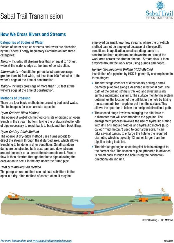
Illustration 1: Exhibit A— How We Cross Rivers and Streams —Sabal Trail
Exhibit B: Surface-Water Quality and Ground-Water Quality —USGS 1999
“Sustainability of Ground-water Resources”, by William M. Alley, Thomas E. Reilly, O. Lehn Franke, U.S. Department of the Interior, U.S. Geological Survey — Publisher, 1 January 1999, Box E on Page 63.
The Connection Between Surface-Water Quality and Ground-Water Quality in a Karst AquiferThe Upper Floridan aquifer, which is the sole source of water supply for Valdosta, Georgia, and much of the surrounding area, receives large volumes of direct discharge from the Withlacoochee River through sinkholes in the streambed or off-channel. A highly interconnected conduit system has developed in the Upper Floridan aquifer in this area, which extends at least 15 miles from the sinkhole area. Chloride and isotopic data were used by Plummer and others (1998) to map the percentage of Withlacoochee River water in ground water in the Upper Floridan aquifer (Figure E-1).
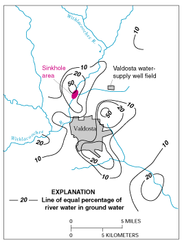
Illustration 2: Figure E-1. Estimated percentage of Withlacoochee River water in ground water in the Upper Floridan aquifer, June 1991. (Modified from Plummer and others, 1998.)These data indicate that ground water in parts of the Upper Floridan aquifer contains high percentages of recently recharged Withlacoochee River water. Plummer and others (1998) note that, although the patterns shown in Figure E-1 are generally true over the area, extreme variations can occur at a given location, as would be expected because of the large variations and discontinuities in hydraulic properties in the karst environment and time-varying inflows of river water into the aquifer.The strong connection between the Withlacoochee River and ground water in the Valdosta area has created concerns about the potential for contamination of ground-water supplies by contaminants in the river. There also are concerns about the effects of natural organic matter in the river water. For example, in the early 1980’s, it was recognized that chlorination of aquifer water produced disinfection by-products in excess of drinking-water standards. This occurred as a result of reaction of chlorine with the high amounts of natural organic matter in the river water recharged to the aquifer.

Illustration 3: Exhibit B— Sinkhole near the Withlacoochee River. (Photograph by Richard E. Krause, U.S. Geological Survey.)
Exhibit C: VSU Prof. Don Thieme and Cherry Creek Sink
Geology Professor Don Thieme of Valdosta State University, “Cherry Creek sink in Withlacoochee River subsiding into aquifer”, YouTube video by WWALS, 9 October 2013, https://www.youtube.com/watch?v=MFrO6Mt10EE
Geology Professor Donald M. Thieme of Valdosta State University, “GPR Fieldwork” slides, 29 October 2014.

4: Exhibit C— VSU Prof. Don Thieme and Cherry Creek Sink.Exhibit D: Sinkhole under a garage, Lowndes County, GA
Picture taken by John S. Quarterman 22 August 2012.

5: Exhibit D— Sinkhole under a garage in Lowndes County, Georgia.
Exhibit E: Sinkhole Under Snake Nation Road, Lowndes County, GA
Picture by Valdosta Daily Times, October 2010.

Illustration 6: Exhibit E— Sinkhole, Snake Nation Road, Lowndes County, GA
Exhibit F: WWALS and Withlacoochee River watershed

Illustration 7: Exhibit F— WWALS watersheds —EPA MyWaters Mapper

Illustration 8: Exhibit F— Withlacoochee River Watershed —EPA MyWaters MapperWWALS watersheds and Withlacoochee River watershed (source: EPA MyWaters Mapper) and Withlacoochee River (source: USGS Streamer).

Illustration 9: Exhibit F— Withlacoochee River —USGS Streamer
Exhibit G: Sabal Trail above vulnerable Floridan Aquifer —FL-DEP
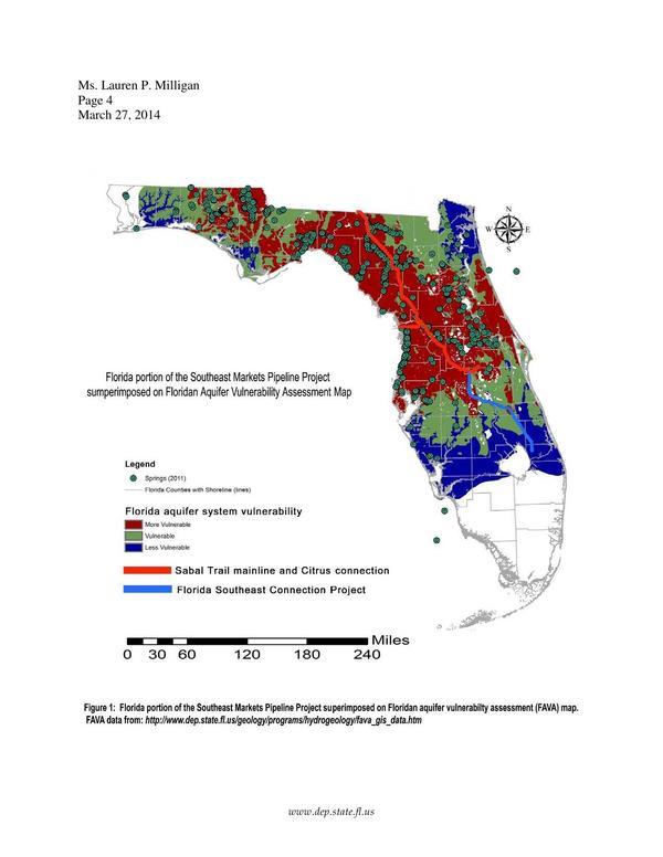
Illustration 10: Exhibit G— Sabal Trail pipeline above vulnerable Floridan Aquifer —FL-DEP
Frank Rupert, P.G. and Guy Means, P.G., “To: Ms. Laura P. Milligan” in “Florida State Clearinghouse comments on Dockets # PF14-1, et al Notice of Intent to Prepare an Environmental Impact Statement for the Planned Southeast Market Pipelines Project (Sabal Trail and Florida Southeast Connection Projects).” Accession Number 20140418-5237, 27 March 2014.
Exhibit H: Floridan Aquifer transmissivity —USGS
Eve L. Kuniansky, Jason C. Bellino, and Joann F. Dixon, “Transmissivity of the Upper Floridan Aquifer in Florida and Parts of Georgia, South Carolina, and Alabama”, Scientific Investigations Map 3204, A Product of the U.S. Geological Survey Groundwater Resources Program, 19 April 2012.

Illustration 11: Exhibit H— Floridan Aquifer transmissivity —USGSExhibit I: A spring on the Withlacoochee River
Chris Mericle, “Our Holly Point Treasures”, by Chris Mericle, YouTube, 13 July 2014, https://www.youtube.com/watch?v=_i6dtB3mF2U

Illustration 12: Exhibit I— A spring on the Withlacoochee River from the video "Our Holly Point Treasures"Exhibit J: Hydrogeology Report: Sabal Trail & Withlacoochee River —David Brown
David Brown, “Hydrogeology Report: Sabal Trail methane pipeline crossing of Withlacoochee River”, 22 August 2014. Included in “RESOLUTION 2015-02,” Hamilton County, Florida Board of Commissioners, 22 August 2014. Both report and resolution included in WWALS Watershed Coalition, Inc., “Motion to intervene and request for extension of filing deadline, by WWALS Watershed Coalition, Inc. under CP15-17.” FERC Accession Number 20141216-5051, 16 December 2014, https://elibrary.ferc.gov/idmws/file_list.asp?document_id=14280938.

Illustration 13: Exhibit J— Cross-section of the proposed HDD crossing of the Withlacoochee River and hypothetical karst features that could result in a hydrofracture (frac-out)

Illustration 14: Exhibit J— Potential sinkhole or collapse feature forming as a result of the proposed HDD crossing of the Withlacoochee River.


Pingback: WWALS at Earth Day by S.A.V.E. at Drexel Park near VSU today - WWALS Watershed Coalition
Pingback: Linkage between ground water and surface water -USGS - WWALS Watershed Coalition